
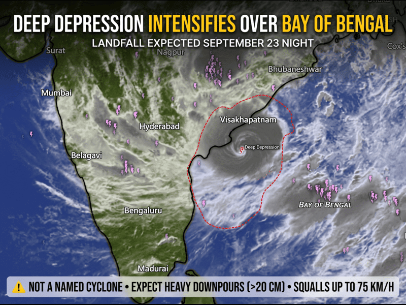
The system is likely to bring a period of intense rainfall along the coast, followed by additional rain farther inland as its circulation moves across central India.
Odisha and Andhra Pradesh face the main rainfall threat
The immediate concern is rainfall rather than the system’s classification.
Parts of southern and coastal Odisha could receive extremely heavy rainfall on September 23 and 24. North Coastal Andhra Pradesh is also expected to experience a period of intense rain during the same window.
Heavy rain could occur over a short period in some locations. This raises the possibility of temporary flooding, water accumulation in urban areas and disruption on roads and other low-lying routes.
Thunderstorms and lightning may accompany the heavier rain.
The exact location of the heaviest rainfall will depend on the system’s final track and the position of its rainbands. A small change in the circulation can shift the most intense rainfall zone, so residents should follow updated local warnings rather than relying on a single forecast map.
Landfall timing is now becoming clearer
The system is moving west-northwestward over the Bay.
Current IMD guidance indicates further strengthening before the circulation reaches the coast. The expected crossing zone lies between Visakhapatnam in Andhra Pradesh and Gopalpur in Odisha.
The present forecast window is September 23 night into September 24 early morning.
That timing is important because coastal conditions can deteriorate rapidly as the circulation approaches. Stronger winds, heavy rain and poor visibility can develop around thunderstorms even away from the centre of the system.
Rainfall could continue after the coast crossing
The weather story will not end when the system moves inland.
Once over land, the circulation is expected to continue carrying moisture into parts of central India. Areas farther west could therefore see additional periods of rain during the following days.
Vidarbha, for example, remains under an IMD heavy-rainfall outlook extending into September 26.
Parts of central India may also see locally heavy showers as the system weakens and moves inland. However, rainfall amounts will become increasingly dependent on the system’s track, moisture availability and local atmospheric conditions.
This is also why numerical-model rainfall maps should be treated as guidance rather than a guarantee of rainfall at a particular location.
Coastal conditions will become hazardous
The approaching system will also affect marine conditions.
IMD expects strong and gusty winds along parts of the North Andhra coast, with wind speeds increasing during periods of heavy rain and thunderstorms. The sea can become very rough during these conditions.
Fishermen and small-boat operators should therefore follow the latest marine warnings and instructions from local authorities.
At present, the IMD coastal bulletin does not indicate a storm-surge or tidal warning. That does not remove the risk from heavy rain, strong winds or rough seas.
What residents should do
People in the potentially affected coastal districts should take a few simple precautions before the worst weather arrives.
- Avoid flooded roads and underpasses. Never attempt to cross rapidly moving water on foot or by vehicle.
- Secure loose objects. Temporary structures, outdoor equipment, signs and other unsecured items can become dangerous in strong winds.
- Stay away from the coastline during rough weather. Beaches, river mouths and exposed coastal areas can become hazardous during thunderstorms and strong winds.
- Take extra care on hilly roads. Heavy rain can reduce visibility and trigger localised rockfalls or slope failures in vulnerable areas.
- Keep monitoring official warnings. Forecasts can change as the system gets closer to land.
What happens next?
The next 24–48 hours will be important for determining the system’s final intensity, track and rainfall distribution.
The September 23–24 period is currently the key window for Odisha and north Coastal Andhra Pradesh. After the coastal crossing, the system is expected to weaken gradually while continuing to influence rainfall farther inland.
WeatherWatch will continue to track the system using official IMD updates and numerical-weather-model guidance. Model maps can help identify developing rainfall patterns, but IMD warnings remain the operational reference for public weather alerts.
FAQ
Is this a cyclone?
No. The system is currently classified as a Depression and is forecast to strengthen into a Deep Depression. It is not currently classified as a Cyclonic Storm.
When is landfall expected?
The current IMD forecast places the coastal crossing between Visakhapatnam and Gopalpur during the night of September 23 and early September 24.
Which areas face the greatest rainfall risk?
Southern and coastal Odisha and North Coastal Andhra Pradesh are currently the main areas of concern, particularly during September 23–24.
Follow the latest bulletins from the India Meteorological Department and local disaster-management authorities. WeatherWatch analysis can provide additional context, but official warnings should take priority.
Source: India Meteorological Department (IMD), September 22, 2026.