
A new weather system is expected to develop over the southeast Bay of Bengal on November 13. The IMD forecasts that it could become a depression around November 15, while a separate Western Disturbance brings rain and snow to northern India.
NEW DELHI, November 12, 2026: The India Meteorological Department (IMD) is tracking a developing weather system over the Bay of Bengal that could strengthen into a depression by November 15.
A low-pressure area is likely to form over the southeast Bay of Bengal around November 13. It is expected to move northwestwards and may strengthen into a well-marked low-pressure area on November 14, followed by a depression around November 15.
The development comes after Cyclones Arnab and Murasu earlier this season. WeatherWatch is monitoring the new system as cloud activity increases over the Bay.
Bay of Bengal records warm sea temperatures
WeatherWatch’s ocean analysis indicates an average sea-surface temperature of around 29.7°C across the Bay of Bengal. Some areas are approaching 30°C.
An ocean analysis image dated November 11 showed a local sea-surface temperature reading of 30°C near 6.08°N and 92.31°E, close to the Andaman Sea region.
Warm ocean water can provide energy and moisture to developing weather systems. However, sea temperatures alone cannot determine whether a system will develop into a cyclone.
Atmospheric conditions, wind shear and circulation patterns also influence the development and strength of tropical weather systems.
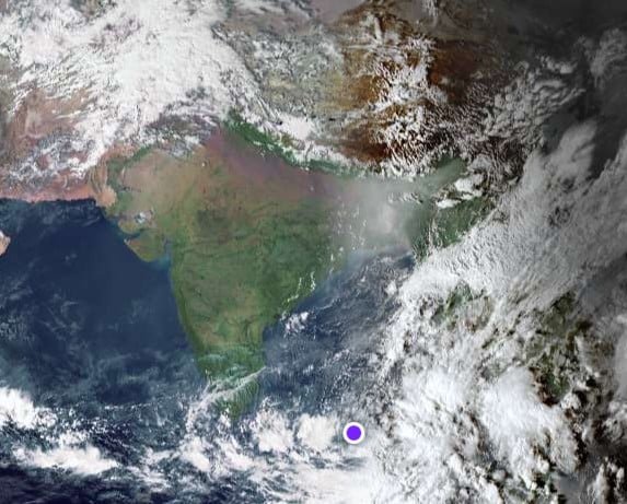
Satellite imagery from Zoom Earth on November 12 at 2:50 pm IST showed widespread cloud activity over parts of the Bay of Bengal. The IMD’s Tropical Weather Outlook also reported intense to very intense convection over parts of the Northeast, Central and South Bay of Bengal and the Andaman Sea.
The cloud development and warm ocean conditions make the system important to monitor as it moves over the region.
Will this become the third cyclone after Arnab and Murasu?
The possibility of another cyclone is likely to attract attention as the new system develops over the Bay of Bengal.
However, the IMD has not declared a cyclonic storm. Its current forecast indicates the possible formation of a depression around November 15.
The IMD’s tropical weather outlook assigns increasing probabilities to the formation of a depression over the forecast period, progressing from low to moderate and then high.
A depression would need to strengthen further before it could be classified as a cyclonic storm.
If that happens, it could become the third cyclone being tracked after Arnab and Murasu this season. For now, cyclone formation remains unconfirmed.
Tamil Nadu and Andhra Pradesh may receive fresh rain
The developing system could influence rainfall over parts of South India from November 14 onwards.
The IMD has forecast fairly widespread to widespread rainfall over Tamil Nadu, Puducherry and Karaikal on November 15. Isolated heavy rainfall is also likely over these areas on November 15 and 16.
Coastal Andhra Pradesh, Yanam and Rayalaseema may receive isolated to scattered rainfall between November 14 and 16.
The rainfall distribution will depend on the system’s movement and further development.
The Andaman and Nicobar Islands are also likely to receive fairly widespread to widespread rainfall between November 12 and 18, with isolated heavy rainfall possible during November 12–16.
Fishermen warned as sea conditions may worsen
The IMD has issued marine warnings for parts of the Bay of Bengal and the Andaman Sea.
Fishermen have been advised not to venture into the Andaman Sea and specified areas of the southeast and adjoining east-central Bay of Bengal during the warning period.
Squally weather is also expected over the affected sea areas. Wind speeds of 40–50 km/h, with gusts up to 60 km/h, have been indicated in the earlier IMD marine outlook for November 14 and 15.
Fishing communities and marine operators should follow the latest warnings before entering the sea.
Western Disturbance brings rain and snow to the Himalayas
While the Bay of Bengal system develops, a Western Disturbance is affecting the northern mountain region.
The IMD expects fairly widespread to widespread rainfall over Jammu and Kashmir and Ladakh on November 12 and 13. Isolated heavy rainfall or snowfall is also possible in the Kashmir Valley on November 12.
Rainfall activity is likely to continue at isolated to scattered places over Jammu and Kashmir and Ladakh on November 14 and 15.
Himachal Pradesh and Uttarakhand may also receive scattered rainfall during this period.
The weather department has warned of thunderstorms, lightning and gusty winds over Jammu and Kashmir and Ladakh. Wind speeds could reach 40–50 km/h, with gusts up to 60 km/h between November 12 and 14.
Travellers should check local weather bulletins and road conditions before travelling to higher areas.
What happens next?
The next few days will be important for monitoring the Bay of Bengal system.
The immediate focus is on the formation of the low-pressure area around November 13 and its possible strengthening into a depression around November 15.
Changes in cloud patterns, ocean conditions and atmospheric circulation will help meteorologists assess its future development.
WeatherWatch will continue tracking the system through satellite imagery, ocean analysis and official IMD bulletins.
Disclaimer: This report is based on IMD forecasts issued on November 12, 2026, and WeatherWatch ocean and satellite analysis. The possibility of a third cyclone is not confirmed. Forecasts may change as the system develops. Follow official IMD warnings and local authorities’ instructions.