
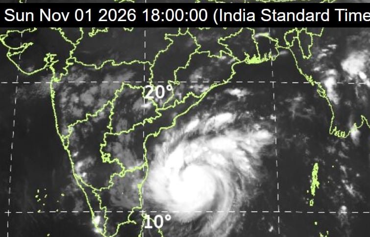
Cyclone Murasu Approaches Andhra Coast, IMD Issues High Alert
The India Meteorological Department (IMD) has issued high alerts for Andhra Pradesh and neighbouring regions as Cyclone Murasu intensifies over the Bay of Bengal.
The weather system, which developed from a deep depression, has strengthened into a Cyclonic Storm and is forecast to become a Severe Cyclonic Storm before making landfall.
As of the latest IMD bulletin issued on 1 November 2026, Cyclone Murasu was located over the southwest and adjoining west-central Bay of Bengal. The system lay approximately 480–550 km east-southeast of Chennai and Nellore. It is currently moving west-northwestwards and is expected to intensify further.
Expected Landfall Details
According to the IMD, Cyclone Murasu is very likely to cross the south Andhra Pradesh coast between Nellore and Narsapur (close to Ongole in Prakasam district) during the midnight hours of 2 November to the early morning of 3 November 2026.
At the time of landfall, the cyclone is expected to pack maximum sustained winds of 100–110 km/h with gusts reaching up to 120 km/h. After crossing the coast, the system is forecast to move further inland while gradually weakening.
Rainfall and Regional Impact
Heavy to extremely heavy rainfall is expected over coastal Andhra Pradesh on 2 and 3 November. Districts likely to be most affected include Nellore, Prakasam, Guntur, Krishna, Bapatla, and parts of West Godavari.
Rayalaseema and several districts of Telangana are also likely to receive heavy rain and strong winds as the outer bands of the system move inland.
Southern Odisha remains under watch, with the possibility of heavy rainfall on 3 and 4 November. Fishermen along the Andhra Pradesh, north Tamil Nadu, and Odisha coasts have been advised not to venture into the sea until at least 4 November.
Official Preparedness
State governments have stepped up emergency arrangements. National Disaster Response Force (NDRF) teams and state disaster response units have been deployed in vulnerable coastal areas. Local administrations have been directed to keep cyclone shelters ready and to monitor low-lying and flood-prone zones closely.
Non-essential official programmes in the affected districts have been reviewed, and control rooms are functioning round the clock to coordinate relief and rescue operations if required.
Safety Advice for Residents
- People living in coastal and flood-prone areas are advised to take the following precautions:
- Secure loose outdoor objects such as roofing sheets, water tanks, flower pots, and furniture.
- Keep adequate stocks of drinking water, dry food, essential medicines, torches, and power banks.
- Avoid unnecessary travel during the period of strong winds and heavy rain.
- Do not venture near the sea or into flooded areas.
- Follow only official updates issued by the IMD and district authorities.
Frequently Asked Questions
What does the name Murasu mean?
The name “Murasu” was proposed by India. It refers to a traditional Tamil drum that was historically used to make public announcements.
Will Cyclone Murasu affect Hyderabad and other inland cities?
The core of the cyclone is expected to weaken after landfall. However, outer rain bands may cause heavy rainfall and gusty winds over parts of Telangana, including areas around Hyderabad.
Where can I check official live updates?
Real-time bulletins, satellite imagery, and tracking maps are available on the official IMD website (mausam.imd.gov.in).