
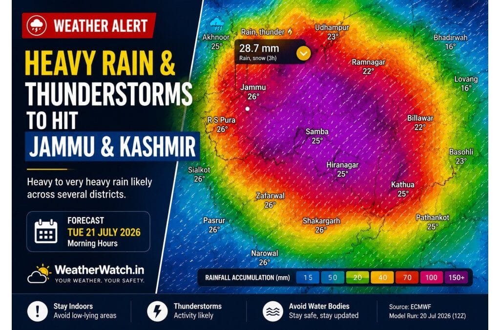
JAMMU | July 18: The Meteorological Centre (MeT), Srinagar, has issued a Jammu Division Rainfall Advisory for July 19–22. The advisory, issued on July 16 by Director Dr. Mukhtar Ahmad, forecasts an active spell of monsoon weather across the region.
According to the forecast, several districts may receive repeated spells of rain. The heaviest rainfall is likely on July 21 and July 22.
The advisory also warns of brief but intense heavy showers, especially over the hill districts. These conditions could trigger flash floods, landslides, mudslides, waterlogging, and rising water levels in vulnerable areas.
Rain is expected across most parts of the Jammu Division. However, rainfall intensity will vary from district to district. Residents should continue following official weather bulletins and local administration advisories throughout the forecast period.
What Happened?
July 19 Forecast
The MeT Centre says July 19 will remain partly cloudy. Many places may receive light to moderate rain and thundershowers. Some areas, particularly in the Jammu region, could also experience brief heavy showers.
July 20–22 Outlook
From July 20 to July 22, skies are likely to remain generally cloudy. The region may witness several spells of light to moderate rainfall.
The department expects the most active phase of the wet spell on July 21 and July 22. During this period, heavier showers may develop over vulnerable districts.
Peak Rainfall Hours
According to the advisory, late afternoon, evening, night, and early morning hours are the most favourable periods for heavier rainfall.
District-Wise Vulnerability Assessment
The NDMA and MeT hyper-local vulnerability assessment places districts into three risk categories based on terrain and flood susceptibility.
🔴 High Vulnerability
- Udhampur
- Doda
- Ramban
- Reasi
- Kishtwar
These districts have a greater risk of flash floods, landslides, mudslides, and rapidly rising streams because of their mountainous terrain and existing geological vulnerability.
🟠 Medium Vulnerability
- Rajouri
- Poonch
- Kathua
Localized heavy rainfall may trigger waterlogging, slope instability, and temporary road disruptions, particularly in hilly areas.
🟡 Lower Vulnerability
- Jammu
- Samba
Although these districts fall within the lower-risk category, isolated heavy showers could still cause urban waterlogging and traffic disruptions, especially in low-lying areas.
Official Advisory
The MeT Centre has urged residents and local authorities to stay alert throughout the advisory period.
The department warns about:
- Flash floods in vulnerable areas
- Landslides and mudslides in hilly districts
- Waterlogging in urban and low-lying locations
- Rising water levels in streams and seasonal nallahs
Officials also advise residents to monitor weather updates regularly and follow directions from local authorities.tor official weather updates, particularly if conditions change rapidly.
Forecast vs Model Guidance
Weather models also suggest an active rainfall pattern across the Jammu Division.
The ECMWF weather model projects about 225 mm of rainfall around Jammu city and nearly 420 mm across parts of the Udhampur–Billawar hill belt over two days.
These figures are model guidance only. They are not official IMD or MeT rainfall forecasts.
Even so, the model broadly matches the official vulnerability assessment. It projects the highest rainfall over the same hill districts that MeT identifies as the most vulnerable.
Safety Advisory
Residents in Udhampur, Doda, Ramban, Reasi, Kishtwar, Rajouri, Poonch, and Kathua should remain alert during the advisory period.
Travelers should avoid non-essential travel through the Chenab Valley and Pir Panjal routes during July 21–22, especially in the late afternoon, evening, night, and early morning.
People should also:
- Avoid crossing overflowing streams.
- Stay away from landslide-prone slopes.
- Follow instructions from district administrations.
What Happens Next?
Monsoon activity is expected to increase from July 19. Rainfall should become more widespread on July 20 before reaching its peak on July 21 and July 22.
The Meteorological Centre, Srinagar, will continue monitoring weather conditions. If needed, it will issue updated forecasts or advisories.
Residents should rely on official weather bulletins for the latest information.
Frequently Asked Questions
The official vulnerability assessment identifies Udhampur, Doda, Ramban, Reasi, and Kishtwar as the highest-risk districts.
According to MeT Srinagar, the peak rainfall activity is expected on July 21 and July 22, particularly during late afternoon, evening, night, and early morning hours.
No. The ECMWF rainfall totals are forecast model guidance and should not be interpreted as official IMD or MeT rainfall forecasts.
Residents should monitor official advisories, avoid unnecessary travel through vulnerable mountain routes during peak rainfall, and remain alert for flash flood and landslide warnings.
Conclusion
The latest Jammu Division Rainfall Advisory points to an active monsoon spell between July 19 and July 22. Hill districts remain the most vulnerable to heavy rainfall and related hazards. Residents should stay informed through official weather updates and follow local administration advisories throughout the forecast period.
Sources
Source: IMD, ECMWF, NOAA (where applicable), and official government weather agencies.
Disclaimer
Disclaimer: Weather forecasts are based on the latest available data and may change. Please follow official advisories from IMD and local authorities for the latest updates and safety guidance.