
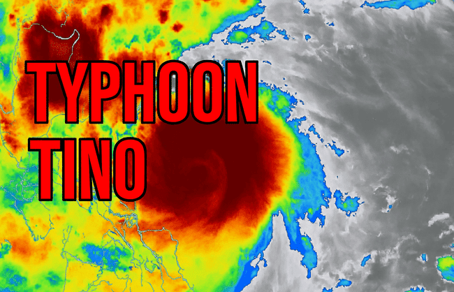
Typhoon Tino, internationally known as Kalmaegi, intensified over the central Philippines on November 3, 2025, bringing destructive winds, heavy rainfall, and coastal flooding across Eastern Visayas and Cebu.
At 8:40 PM local time, satellite imagery revealed a well-defined eye and towering cloud tops, indicating peak intensity. The storm made landfall in Southern Leyte, then crossed Cebu province, triggering landslides and widespread power outages.
Key Details
- Wind Speed: Sustained winds of 150 km/h, gusts up to 205 km/h
- Movement: Westward at 25 km/h
- Wave Heights: Up to 3.7 meters offshore
- Affected Areas: Eastern Samar, Leyte, Cebu, Negros Occidental, Northern Mindana
Emergency Measures
Local authorities raised Tropical Cyclone Wind Signal No. 4 in multiple provinces. Evacuations were ordered in flood-prone zones, and classes were suspended across affected regions. Early reports confirmed localized flooding and a landslide in Tabuelan, Cebu, with no casualties reported.
Tracking & Forecast
Typhoon Tino is expected to continue westward into the South China Sea, gradually weakening over the next 24–36 hours. Live tracking and satellite updates are available via:
- Zoom Earth – Typhoon Kalmaegi Tracker
- PAGASA Bulletin – Typhoon Tino
📢 For more live updates, follow Weather Watch:
📸 Instagram: @weath_erwatch
📘 Facebook: Weather Watch
🌐 Website: weatherwatch.in
Stay safe and informed. Follow local authorities and emergency updates.